

Cleanup, rescue operations underway in Japan after severe rains kill over 200 people and strand thousands in the recent flooding and landslides in west Japan.
On Mar 11, 2011, a devastating 9.0-magnitude quake struck under the Pacific Ocean, and the resulting tsunami caused widespread damage and claimed tens of thousands of lives.
It also sent three reactors into meltdown at the Fukushima nuclear plant, causing Japan’s worst postwar disaster and the most serious nuclear accident since Chernobyl in 1986.
The devastating tsunami hit sites along the Tohoku coast.
A public beach just opened in Rikuzentakata on July 20, 2018 for the first time in eight years, underscoring the destruction of sites.
In 1703, an 8.2 magnitude earthquake(Genroku earthquake) along the Sagami Trough triggered a tsunami that rippled towards Japan’s then capital, Edo. It is estimated that a couple of thousands lives were lost.
Japan has a lot of natural disasters and many foreign investors are worrying about it.
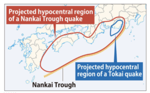
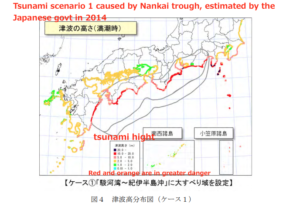
A major earthquake is expected to strike sometime along the Nankai Trough, a submarine trench running off the Japanese archipelago from around Shizuoka Prefecture in Honshu to the seas east of Kyushu.
How at risk is Tokyo Bay from future tsunami by Nankai Trough earthquake ?
The Nankai Trough is a 700-kilometer-long sea-bottom depression that runs about 100 km off the southern coast from Shizuoka Prefecture to the Shikoku region.
According to a government projection, the death toll from a magnitude-9.0 or stronger quake and tsunami occurring along the depression could be as high as 320,000. The issue is of importance if not only because active development on reclaimed land in Tokyo Bay, where the new Tsukiji market is located and the Olympic Village will be built, puts structures and lives at possible risk.
The findings by a group of government-appointed scientists showed that some 227,000 households would need to be evacuated from Aichi Prefecture to more distant areas, followed by some 188,000 in Shizuoka Prefecture.
The team predicts such a quake is also likely to cause severe damage in the central Tokai region facing the Pacific.
In 2013, Tokyo Metropolitan government issued the report regarding the potential risk by Nankai Trough earthquake which could take place in coming two to three decades.
(From Mainichi shimbun)
“Nankai megathrust earthquakes are great megathrust earthquakes that occur along the Nankai megathrust – the fault under the Nankai Trough – which forms the plate interface between the sub-ducting Philippine Sea Plate and the overriding Amurian Plate (part of the Eurasian Plate),
which dips beneath southwestern Honshu, Japan.
The fault is divided into five segments in three zones, which rupture separately or in combination, and depending on location, the resulting earthquakes are subdivided by zone from west to east into Nankai earthquakes, Tōnankai earthquakes, and Tōkai earthquakes.” (from Wikipedia)
Over a couple of hundred years, a few earthquakes occurred with a return period of 100-200 years.
All of these great earthquakes have resulted in damaging tsunamis.
The area remains seismically active, and future earthquakes are anticipated, with a high risk of a Nankai earthquake in the near future, which could be potentially very damaging.
It is estimated that around 90 percent of municipalities would consider urging residents to evacuate based on signs that a powerful earthquake, including a secondary temblor, could strike the Nankai Trough, an Asahi Shimbun survey showed.
Such widespread evacuations could affect millions of people.
The timing of the earthquake is impossible to predict.
How does it affect Tokyo ?
The Tokyo government analyzed Tsunami height, flooded area, human and building damage using the country’s Nankai Trough gigantic earthquake model (basis Magnitude 9 class).
From the plurality of seismic source models indicated by the central government, Tokyo government assumed a seismic intensity distribution in the city using a model with the greatest fluctuation for the metropolitan area.
Among the multiple wave source models indicated by the central government, the model with the largest tsunami height in Tokyo is estimated.
The report covers each coast of Tokyo Bay and the islands of the Izu Islands and the Ogasawara Islands.
Summary
According the report by Tokyo Government, the maximum seismic intensity, liquefaction risk, tsunami height
are lower than the assumed results such as the earthquake striking directly under the capital city.
Most of the area will have a seismic intensity of less than 5.
The maximum tsunami height on mainland Tokyo is 2.48 m (Koto Ward), which is lower than 2.61 m (Shinagawa Ward) of Genroku earthquake in 1703. But a lot of small islands in Tokyo Metropolitan are exposed to very high risk of massive tsunami. In some small islands, the report is warning tsunami as high as 35 meters. Obviously the areas exposed to higher risk are also laying from Shizuoka to Kagoshima.
Here are the charts showing the warning of Seismic intensity(震度), Liquefaction(液状化)and Tsunami in Tokyo bay.
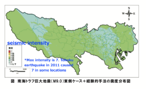
(Seismic intensity warning)
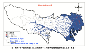
(Liquefaction warning)
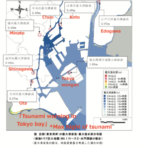
(Tsunami warning in Tokyo Bay)
Tsunami warning of coastal sites
The map shows warning of tsunami risk as high as 20m+ (red line)
Final thought
Tokyo in mainland is not in massive danger but other areas need to be prepared for a big one.
One report says Dr. Robert Geller, professor of geophysics at the University of Tokyo, has criticized the government for focusing on one particular scenario. He said the government’s conclusion are based on a wrong model thus are false.
We need to understand the earthquakes are not cyclical and the earth’s movements are very unpredictable.
It is impossible to predict where and when the next major earthquake will occur.
Therefore Japan always needs to be prepared for a sudden earthquake like the one in Tohoku in 2011.
Even it looks nice and cool, avoid buying a property in the coastal sites (especially lowlands) at high risk of massive tsunami.
Useful links for Nankai Trough earthquake
Latest Nankai Trough earthquake damage estimate by the Japanese gov (in Japanese only)
Tokyo Metropolitan report on Nankai Trough earthquake (in Japanese only)
Other Helpful Articles
How to avoid the severe flooding in Japan ? : Over 200 people died in recent floods and landslides
Real estate investment Japan : Liquefaction risk caused by earthquake in Tokyo
Risks in real estate investment in Japan-natural disaster- : How to avoid the earthquake risk
Toshihiko Yamamoto
Real estate investing consultant and author.
Founder of Yamamoto Property Advisory in Tokyo.
International property Investment consultant and licensed
real estate broker (Japan).
He serves the foreign companies and individuals to buy and sell
the real estates in Japan as well as own homes.
He holds a Bachelor’s degree in Economics from
Osaka Prefecture University in Japan
and an MBA from Bond University in Australia
Toshihiko’s book, “The Savvy Foreign Investor’s Guide to Japanese Properties: How to Expertly Buy, Manage and Sell Real Estate in Japan”is now out on Amazon, iBooks (iTunes, Apple) and Google Play.
About the book
Amazon.com Link